Spartly Island
Why in news?
There is a significant acceleration of Vietnam's island-building activities in Spartly Island, with which Vietnam poised to match or even surpass China's extensive land reclamation in the area.
About
- Since early 2025, Vietnam has intensified its land reclamation, extending artificial land to eight previously untouched reefs, including Alison Reef, Collins Reef, East Reef, Landsdowne Reef, and Petley Reef.
- By March 2025, Vietnam had created about 70% as much artificial land in the Spratlys as China, and current activity nearly guarantees Vietnam will soon match or exceed China's reclamation scale.
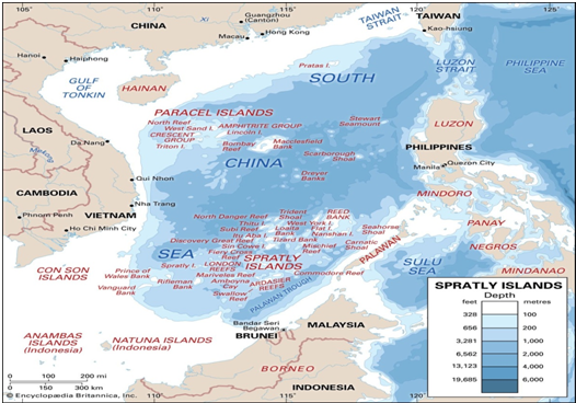
Spratly Islands
The Spratly Islands are a large, disputed archipelago of reefs, shoals, atolls, and small islets in the South China Sea, located roughly midway between Vietnam and the Philippines and north of insular Malaysia.
Geographic and Economic Overview
- The Spratly Islands are spread over an area of about 158,000 square miles (409,000 square kilometers), but the land area is tiny, consisting of more than 100 small islands or reefs, many of which are submerged.
- The largest naturally occurring islet is Itu Aba (36 hectares), and another significant feature is Spratly Island (also known as Storm Island), which is 15 hectares.
- The islands have almost no arable land, limited freshwater resources, and no permanent civilian population. Wildlife is mostly restricted to turtles and seabirds.
- Key resources in the area include fish, guano, oil, and natural gas reserves, and the surrounding waters are a major shipping lane.
Strategic and Political Importance
- The Spratlys are highly contested, with overlapping claims by China, Taiwan, Vietnam, the Philippines, and Malaysia.
- Several countries have built airstrips, harbors, and military outposts, and there is ongoing land reclamation and infrastructure construction, particularly by Vietnam and China.
- The area is strategically crucial due to its location along vital maritime routes and potential energy resources.
Recent Developments
- There is escalating land reclamation, especially by Vietnam, which aims to match or surpass the scale of Chinese activities in the region.
- The islands remain a flashpoint for regional security and international maritime law debates, with regular diplomatic tensions among claimants.
Notable Features
- Map detailing the Spratly Islands in the South China Sea, indicating features above high tide (black type) and submerged features (blue type), with a noted erratum for Hughes Reef
- The northeast is called "Dangerous Ground," known for navigation hazards due to many submerged reefs and abrupt coral outcrops.
- Spratly Island (Storm Island), managed by Vietnam, has seen significant land reclamation, expanding to about 36.5 hectares with new harbor and extended runway by 2025.
- The archipelago's official names vary by claimant: for example, Nansha Qundao (China), Kepulauan Spratly (Malaysia), Pangkat Islang Kalayaan (Philippines), and Quan Dao Truong Sa (Vietnam).
Download Pdf


Get in Touch